1-10 of 21 results
-
Fusing Satellite and Drone Data with GIS to Create New Analytical Decision Support Tools for Varying Farm Types
PI Kevin Adkins
PI Nickolas Macchiarella
CO-I Ronny Schroeder
CO-I University of Michigan School for Environment and Sustainability (SEAS) and the Department of Ecology and Evolutionary Biology
The synergy between moderate resolution satellite imagery and fine resolution drone imagery, LiDAR data, and meteorological data, along with generally available GIS data, must be identified and optimized. These data will be integrated to produce a variety of products that help identify what tools, inputs, and management strategies most effectively contribute to an increase in the productivity and resilience of an important agricultural system to a major weather or climate related disturbance.
Satellite imagery has been used in agriculture for some time and the increasing implementation of drones into agriculture and agriculture science holds unique promise. However, the synergy between moderate resolution satellite imagery, fine resolution drone imagery, fine resolution LiDAR (Light Detection And Ranging) data, fine-resolution meteorological data, and generally available GIS (Geographic Information Systems) data must be identified and optimized. To be most useful, this fusion of data should help provide estimates in the health and yield of agriculture systems as well as insight into the microclimate and ecosystem variation within a farm site. These data will be integrated to produce a variety of fine-resolution maps that can be analyzed to identify what tools, inputs, and management strategies most effectively contribute to an increase in productivity, agroecological system health, and resiliency or restoration (typically in response to weather or climatic disturbance) of a given farming operation and site. This research will apply these data science methods and tools to varying farm types in Puerto Rico. We expect new insight into how the fusing of a multitude of data can be effectively integrated into an agriculture operation and, subsequently, determine which outputs are most valuable to the varied farm types, practices, and locations. This investigation will also provide critical information on the resistance and resilience of an important agricultural system to major weather or climate-related disturbances and, subsequently, inform management decisions related to climate change adaptation.Categories: Faculty-Staff
-
GUMP: General Urban Area Microclimate Predictions Tool
PI Kevin Adkins
CO-I Nickolas Macchiarella
CO-I National Aeronautics and Space Administration NASA
Hyperlocal weather predictions are often necessary in order to determine whether a particular sUAS route will be safe to fly. The General Urban area Microclimate Predictions tool (GUMP) seeks to provide such predictions through the use of machine learning (ML) models and computational fluid dynamics (CFD) simulations. The computed wind flow field is converted into an intuitive risk map for sUAS operators through the use of appropriate thresholds on wind velocities.
Adverse weather conditions, particularly, high winds, can have a highly adverse impact on small unmanned aircraft system (sUAS) operations. These conditions can vary significantly within a small area (particularly, in an urban environment); thus, hyperlocal weather predictions are often necessary in order to determine whether a particular sUAS route will be safe to fly. The General Urban area Microclimate Predictions tool (GUMP) seeks to provide such predictions through the use of machine learning (ML) models and computational fluid dynamics (CFD) simulations. Specifically, ML models are trained to ingest mesoscale forecasts from the National Oceanic and Atmospheric Administration (NOAA) and output refined forecasts for some specific location, typically, a weather station that serves as a source of ground truth data during training. At the same time, CFD simulations over 3D models of structures (e.g., buildings) are utilized to extend the refined forecast to other points within the area of interest surrounding the location. Because it is difficult to perform such simulations in real-time, they are executed offline under a wide range of boundary conditions, generating a broad set of resulting wind flow fields. During deployment, GUMP retrieves the wind flow field that is most consistent with the ML model’s forecast. The wind flow field can be converted into an intuitive risk map for sUAS operators through the use of appropriate thresholds on wind velocities. I addition to NASA, additional partners on this project are Intelligent Automation Inc. and AvMet.Categories: Faculty-Staff
-
Evaluating Preflight Weather Briefing Strategies
PI Elizabeth Blickensderfer
CO-I Thomas Guinn
CO-I Robert Thomas
The objective of this grant is to examine General Aviation (GA) pilots’ capability to conduct Preflight Weather self-briefings as compared to using Flight Services to obtain weather briefings. Previous research indicates that GA pilots are increasingly conducting weather self-briefings during preflight (Duke et al., 2019). Additional research indicates that GA pilots have moderately low performance when interpreting aviation weather observation and forecast products (Blickensderfer et al., 2019). Research is needed to assess and understand the attitudes, knowledge, and performance of GA pilots conducting self-briefings to identify possible gaps and, in turn, provide recommendations for future system design and pilot training.
Categories: Faculty-Staff
-
Using Virtual Reality to Identify Cybersecurity Threats for Navy Midshipmen
PI Andrew Dattel
CO-I Omar Ochoa
CO-I Daniel Friedenzohn
CO-I Trevor Goodwin
CO-I Harry Brodeen
This research is investigating the training of U.S. Navy Midshipman enrolled in the Reserve Officer Training Corps (ROTC) at Embry-Riddle Aeronautical University (ERAU) to identify cyber and security threats in a simulated bridge of a Navy vessel. Midshipmen will receive classroom instruction, as well as training in a virtual reality bridge simulator. The knowledge and skills training the midshipmen received is intended to transfer to the applications of midshipmen’s future positions and careers.
Cyber and security threats are burgeoning tactics being used in wartime affairs. The first line of defense of a vulnerable vessel is for the crew to distinguish misinformation from factual information. To increase the preparedness of cybersecurity threat awareness, the Office of Naval Research is interested in innovative training initiatives at colleges and universities that support Reserve Officer Training Corps (ROTC) programs. Twenty Embry-Riddle Aeronautical University (ERAU) enrolled in Navy ROTC will be recruited to participate in an 8-week long training program. These 20 midshipmen will participate in traditional classroom instruction, practice on a bridge (i.e., ship control room) virtual reality (VR) simulator, and participate in a specifically designed VR bridge application. This VR application is being designed by the XR Lab in the College of Aviation.
In the classroom setting, midshipmen will receive instruction in theoretical and practical applications to identify cyber and electronic warfare threats. This instruction will go beyond any cybersecurity training that may have been received in previous courses offered by the Naval Sciences curriculum. Group discussion and activities to encourage inquiry-based learning will fulfill some of the classroom requirements and when participating in the VR bridge application.
Midshipmen will also receive a few hours of practice in the Conning Officer Virtual Environment (COVE) simulator. The Cove simulator is designed to allow students to practice navigating ship maneuvering without the risk and expense of operations at sea. However, the COVE simulator does not permit the injection of misinformation experienced in a cyber-intrusion situation.
A VR application will replicate the bridge of a Navy vessel and immerse the operators in a VR environment. This application will permit subtle cyber threats to be introduced during the scenario. The first phase of the application will include three primary resources of the bridge: the Automatic Identification System (AIS), the Voyage Management System (VMS), and Radar. The AIS is based on a transponder system and functions as a broadcast messaging system. The VMS functions as the navigation charting display and is partially based on the Global Positioning System (GPS). Threats such as misinformed broadcast information, erroneous navigation position (e.g., showing own vessel traveling in an untrue heading), and radar misinformation (e.g., showing a friendly ship as an enemy ship) are potentially vulnerable by hacking and other nefarious actions.
Midshipmen in the Trainee position will spend several hours in the VR simulator identifying these cyber threats. Midshipmen will also spend time in the Instructor position to execute command functions that introduce the misinformation. This role of Instructor will show the midshipmen when a threat is introduced and how the Trainee responds. There will be three to four midshipmen observers during any given scenario. After each scenario, the Trainee, Instructor, and Observers will discuss hits and misses that occurred during the scenario. In addition to cohort discussion periods, performance feedback will be given by the instructors.
Research Design
This research will utilize a 2 x 2 mixed quantitative design. Twenty midshipmen (the experimental group) will complete a pretest before starting the curriculum and a posttest after completing all aspects of the curriculum (traditional classroom instruction, participation in the COVE simulator, and participation in the specifically designed VR simulation). A control group that will receive the pretest and posttest will be compared to the experimental group. Evaluation metrics will include accuracy and response time to threats in the VR simulations and measurements of the skills developed in the COVE simulator and knowledge acquired in classroom instruction and the specifically designed VR simulation. At the end of the study, participants will complete a survey consisting of forced-choice and open-ended questions about their experience, self-efficacy, and opinions about the 8-week long study.
This study intends to train midshipmen to be better prepared to identify cybersecurity threats in their future positions and career following graduation from the program. The specific VR application is being designed to be sustainable to be further utilized for the future Naval curriculum and other applications.
Categories: Faculty-Staff
-
UAS Parameters, Exceedances, Recording Rates for ASIAS
PI David Esser
The project was to support aggregation of UAS flight data with commercial, general aviation and surveillance data, to develop enhanced safety analyses for NAS stakeholders, support UAS integration in the NAS, and support the Unmanned Aircraft Safety Team (UAST).
The purpose of the project was to enable the safe integration of UAS in the NAS through building upon existing aviation database and data-sharing efforts encouraged and endorsed by participating government-industry entities. Through this research, a data architecture for unmanned air and ground vehicles and operations was developed in alignment with the FAA’s Aviation Safety Information and Sharing (ASIAS) program.
This project designed and evaluated Flight Data Monitoring (FDM) for unmanned operations and integrated that data into the Aviation Safety Information Analysis and Sharing (ASIAS) system. In addition, this project identified current Unmanned Aircraft Systems (UAS) FDM capabilities and practices, including refresh/recording rate and robustness, and developed guidance for a UAS FDM standard. The UAS community has specific and disparate needs in relation to manned aviation, such as the need for strong cyber-security measures regarding telemetry streams and the storage of sensitive UAS flight data. This project sought to identify the best governance practices regarding the use and research involved with UAS flight data. The project team included original members who designed and deployed the National General Aviation Flight Information Database (NGAFID) which has successfully integrated and is data-sharing with ASIAS.
This project identified UAS FDM events, including event definitions and exceedances, using the normal ASIAS techniques. Future phases of this project will include the actual deployment of a UAS database which interfaces with ASIAS similar to other safety reporting programs.
Categories: Faculty-Staff
-
UAS Flight Data Research in Support of ASIAS (Aviation Safety Information and Analysis Sharing)
PI David Esser
This research will aggregate high quality UAS flight data with commercial and general aviation flight data and surveillance data, in order to develop enhanced safety analyses for NAS stakeholders and to support UAS integration in the NAS.
The overarching purpose of this research is to enable safe integration of UAS in the NAS through building upon existing aviation database and data-sharing efforts encouraged and endorsed by participating government-industry entities. Through this research, a data architecture for unmanned air and ground vehicles and operations will be developed in alignment with the FAA’s Aviation Safety Information and Sharing (ASIAS) program.
This project will design and evaluate Flight Data Monitoring (FDM) for unmanned operations and integrate that data into the Aviation Safety Information Analysis and Sharing (ASIAS) system. In addition, this project will integrate the findings from ASSURE project A20, which identified current Unmanned Aircraft Systems (UAS) FDM capabilities and practices, including refresh/recording rate and robustness, and developed guidance for a UAS FDM standard. The proposed team includes original members who designed and deployed the National General Aviation Flight Information Database (NGAFID), which has successfully integrated and is data-sharing with ASIAS.
Categories: Faculty-Staff
-
Workplace Accident Survey
PI Mark Friend
Random employees of unspecified companies will be interviewed to ID cause(s) of accidents in which they were involved. The goal is to determine if they could have been prevented by adjustments to the overall sysem.
Individuals will be selected based on their availability and asked nine questions and possibly additional questions for clarification, depending on their responses to each. The goal is to determine if adjustments in the employer system could have been made to have prevented hte accident.Categories: Faculty-Staff
-
Implementing Active Learning Techniques in an Undergraduate Aviation Meteorology Course
PI Daniel Halperin
PI Joseph Keebler
CO-I Robert Eicher
CO-I Thomas Guinn
CO-I Kim Chambers
Student feedback from end-of-course evaluations repeatedly indicated a desire to change the format of the course by de-emphasizing the PowerPoint-based lectures. The goal of the present study was to determine whether including a set of new active-learning techniques in an Aviation Weather course would result in better student understanding (as measured by exam scores) and make the course more engaging (as measured by end-of-course evaluations). During 2018-19, three instructors implemented five different active-learning techniques into their classes (i.e., the experimental group), while two instructors continued to use the unrevised course materials (i.e., the control group). The new active-learning techniques, described below, included daily quizzes, polling questions, flipped classroom sessions, in-class activities, and assertion-evidence-based lectures. All sections used the same assignments and exams, allowing for direct assessment of the effectiveness of the active-learning techniques. Analyses of Variance (ANOVA) tables were used to determine the statistical significance of the differences in exam scores. Indirect assessments in the form of end-of-course evaluations were also examined.
Categories: Faculty-Staff
-
Adding Tropical Cyclone Verification Capabilities to the Model Evaluation Tools – Tropical Cyclone (MET-TC) Software
PI Daniel Halperin
Producing reliable tropical cyclone (TC) genesis forecasts is an operational priority. The National Hurricane Center uses several TC genesis guidance products for their Tropical Weather Outlook. Furthermore, global model output is used in many TC genesis guidance products and is considered an important source of deterministic TC genesis forecast guidance. This project creates a standard framework for verifying deterministic and probabilistic TC genesis forecasts using the TC-Gen tool in the Model Evaluation Tools software package.
Accurately predicting tropical cyclone (TC) genesis is an important component of providing the public with the information they need to protect life and property in the event of a landfalling storm. The National Hurricane Center (NHC) issues probabilistic forecasts of TC genesis within two and five days in their Tropical Weather Outlook product. There are several guidance products available to the forecasters, many of which rely at least in part on global forecast models. It is important to understand how accurate these guidance products and the global models are at forecasting TC genesis.
This project seeks to create a standard framework for verifying TC genesis forecasts from various sources. This will allow a straightforward comparison between official forecasts, the experimental guidance products, and global model forecasts. These verification capabilities are developed within the existing Model Evaluation Tools (MET) software package from the National Center for Atmospheric Research (NCAR). As such, the user will have considerable flexibility when setting up a verification task. They will also be provided numerous output statistics for deterministic and probabilistic forecasts.
Categories: Faculty-Staff
-
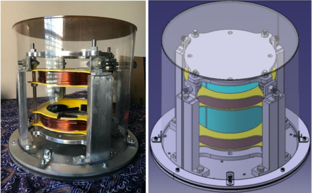
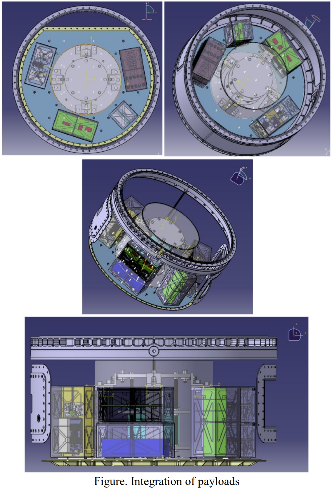
PLD Space Suborbital Microgravity Research
PI Pedro LLanos
This project involves the design, development, integration, testing, validation, and verification of various payloads to be flown aboard PLD Space’s MIURA-1 suborbital rocket.
1. Magnetic Active Propellant Management Device (MAPMD) experiment (student involvement)2. In-vitro experiment comprised of both T-cells and Cancer cells3. Cerebrospinal fluid (CSF) shunt experiment (student involvement)4. Environment characterization of the suborbital vehicle experiment (student involvement)
The first payload is a technology demonstration experiment and will consist of testing and validating a hybrid membrane a viable Magnetic Active Propellant Management Device (MAPMD) proof of concept. This technology is already being tested in a parabolic flight through NASA’s Flight Opportunities Program. This MAPMD is a patented technology developed by ERAU and has demonstrated effective slosh suppression in 1g laboratory setting.
The second experiment's objectives will be to further elucidate the mechanisms altering T‐cell behavior under microgravity (expanding our previous research) and examine the microgravity effect on tumor microenvironment with cancer cells (breast and colon). The third experiment objective is to determine the microgravity effects on intracranial pressure by regulations of a cerebrospinal shunt. This research study is aimed to characterize the effects of fluid shift in a shunt generated by changes in the attitude of the rocket. The fourth experiment will be an avionics box with state‐of‐the‐art sensors to measure the environmental conditions of the rocket and compare these flight parameters with the flight provider.
1. MAPMD will enhance the TRL level achieved with previous payloads launched on NASA’s Zero-G parabolic flights. This research will expand our knowledge of fluid behavior management under various flight stressors while enhancing the aerospace technologies of the suborbital market and future orbital endeavors.
2. The In-vitro experiment will enhance our understanding of the biomechanics of cells using novel state-of-the-art technologies. To our knowledge, this will be the first time that these technologies will fly on a suborbital flight. This research will expand the basic applied research answering fundamental science questions. This project is described in more detail in its own section.
The shunt experiment will improve our knowledge on whether people (with hydrocephalus medical condition) could, one day, fly to space. This research is intended to answer basic applied research questions.
3. The telemetry experiment is another S.T.E.M. payload from which researchers expect to gain valuable data of the flight profile and the conditions inside the rocket that may affect other payloads.
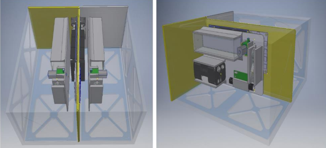
4. The telemetry experiment is another S.T.E.M. payload from which researchers expect to gain valuable data of the flight profile and the conditions inside the rocket that may affect other payloads.
Categories: Faculty-Staff
1-10 of 21 results